


Google Launches Global Fishing Watch Tool at World Parks Congress
As Oceanic Fish Populations Become Rapidly Deplete, Google Has Joined The Fight For Sustainability By Developing A Free Tool Designed To Show All Of The Trackable Fishing Activity In The Ocean.
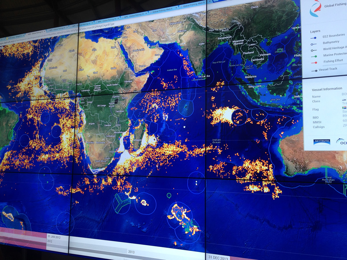
The Global Fishing Watch tool, currently in Prototype stage, was launched today at the 6th IUCN World Parks Congress event in Sydney, a conference bringing together over 5,000 delegates from over 170 countries to discuss the future of protected areas, our planet’s environment and sustainability.
During their presentation, Google along with project technology partners SkyTruth and Oceana discussed how the tool will be made available to the public, enabling users to monitor when and where commercial fishing is happening around the world. This allows global citizens to use the tool from the comfort of their own home to see if their fishieries are being managed effectively, whilst inversely allowing fishermen to be able to prove they are obeying international and environmental laws and guidelines.
The tool feeds of data captured by satellites as part of the Automatic Identification System (AIS) tracking, which automatically classifies vessels activity as either ‘fishing’ or ‘non-fishing’. The prototype contains 300 million AIS points of data covering over 25,000 vessels.
Google displayed how the data can be broken down to track fishing vessels from each country, whilst also mapping the borders of environmentally protected areas, officially licensed fishing boundaries.
Google also presented their work in mapping oceanic sub-surface areas, wildlife, biodiversity and ecosystems – with their work with the Catlan Seaview Survey – highlighting that the platform allows a large consumer audience to virtually explore underwater worlds from the comfort of their own computers or mobile phones.
The Catlan survey is available in 27 countries with imagery captured off the coastlines of 5 different continents.
When asked a question about the idea for the Seaview survey, a Google representative stated it came from Google’s street view idea, only taking it underwater. The survey is also being used for scientific data collection, with Google discusses how coral bleaching is being documented and recorded with underwater images captured by their teams.
Oceanic explorers around the world can now see what life is like under the ocean thanks to Google and Catlin Seaview Survey. Underwater treasures like the Great Barrier Reef can now be explored using the Google Maps environment.
Watch a short video about the Global Fishing Watch Tool HERE
Access the Global Fishing Watch Tool HERE
Access underwater worlds HERE